Posts

Resources on Coriolis forces use in external ballistics

Over and over and over and over and over again the experts tell you that at VERY LONG ranges the Coriolis and Eötvös effects matter and are used in the calculations used to aim ballistic artillery and rifle fire... to deny the VAST body of evidence on the word of some anonymous & unverified source is utterly ridiculous and just shows profound epistemic bias. Application to Long-Range Artillery - Shelling Paris in WW1 Military: THE FIELD ARTILLERY JOURNAL (1918) Fire Control Fundamentals (287389 O-54-4) Long Range Shooting: External Ballistics – The Coriolis Effect Earth's Curvature and Battleship Gunnery (Blog) US Navy: OP 770 -- RANGE TABLES FOR 16"/50 CALIBER GUN 4DOF™ Ballistic Calculator
Simple Proof of the Globe: Distances Between 4 Cities

Image
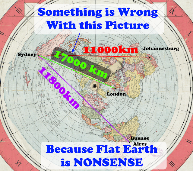
As discussed previously in  Flat Earth Challenges , checking distance and area measurements is a fairly simple way to show it is impossible to map our Earth to a flat plane. Just pick 4 cities that are all fairly distant from one another (8000 km or more is perfect).  The distances don't even have to be all that accurate, as we will show in our example.  If you pick 4 cities that are closer to each other then you need more accurate distances.  I don't want to have to care that much about having super accurate distances, I want something that is glaringly obvious. For my example I've used Sydney, Johannesburg, Buenos Aires, and London -- which I've also used before to show how utterly ridiculous the Gleason map is... But that's just one Flat Earth map.  Let's destroy all Flat maps in one go... The Method What I did is pick the cities with the three longest routes and placed those first three cities that distance apart on a flat plane (Sydney, London, Buenos Aires...

Mt. Rainier's Shadow

Image
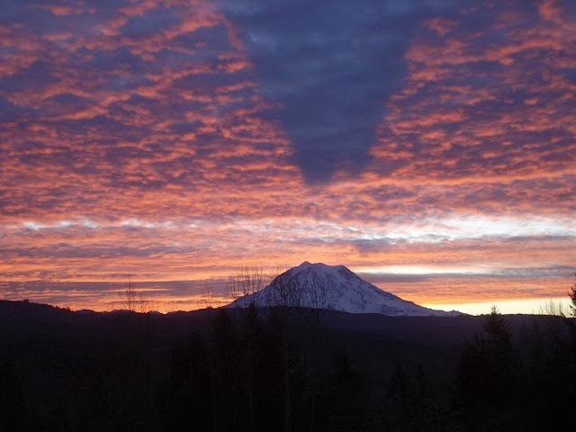
This image of Mt. Rainier taken by Shannon Winslow  (author of historical fiction in the tradition of Jane Austen) features a shadow that is cast upwards on the clouds with a clear gap between the mountain top and the shadow. Image Credit: Shannon Winslow Blog The EXIF data shows: PENTAX Optio S5i | 10.2mm F3.5 1/50 ISO100 | 2011:12:13 08:39:53  This places the Sun over South America, near Latitude: 23° 09' South, Longitude: 70° 58' West as shown by Date and Time -- along a heading of about 134 degrees. Date and Time Source And since we're right in line with the shadow this puts us Southeast of Tacoma, possibly near the Orting/Carbonado area.  But there are no bodies of water Southeast of Mt Rainier that would explain the upward casted shadow. Much less the EXTREME grasping at straws this represents from the Flat Earth crowd given where the Sun is overhead... But it makes perfect sense on a Globe. Indeed, if we pull back as far as we can in Google Earth (which isn't ...

How much should the moon appear to shift between two positions on Earth?

Let's say we have two people viewing the moon who are 10300km apart along the same line of latitude at the same time. How much of a shift against the more distant background stars should the moon appear to shift? This approximation assumes that the sublunar point is roughly between the two observers. Well, first we need to find their actual linear distance (rather than the distance over the curvature of the Earth, which is what you get from Google Earth). Let's define our variables: \[ R = 6371393 m \;\; \text{Earth Average Radius} \] \[ d = 10300000 m \;\; \text{Earth distance along curvature} \] We can find the angle in radians from the arc length using: \[ \theta = d/R \] and we can find the length of a chord using the half-sine rule: \[ \text{crd} \, \theta = 2 \sin \frac{\theta}{2} \] Plugging that in we find that the straight-line distance is slightly shorter than around the curvature: \[ 6371393 \times 2 \sin(\frac{1}{2} \frac{10300000}{6371393}) \approx 9214000m \] Nex...

Kepler's Laws from Newton

Image
Nothing new here, just wanted to capture these proofs into a single location for easy reference. I've tried to arrange them into a form that is easy to understand and follow. Kepler's First Law: Ellipses \(\require{cancel}\)Proof that a Newtonian force between two masses will produce an elliptical orbit - this is a very textbook approach using polar coordinates, I'm just capturing it here for reference. There are many other approaches , and this has likely been done millions of times now. Remember that Newton's Law is: \[ \begin{align} F &= G \frac{Mm}{r^2} \\ &\therefore \nonumber \\ F &= m a \end{align} \] We define a unit vector in the radial direction \( \hat{r} \) along the angle \( \theta \): \[ \hat{r} = \hat{x} \cos \theta + \hat{y} \sin \theta \] Therefore \( \hat{r} \) changes as per angle \(\theta\) perpendicular to \( \hat{r} \), giving us the tangential unit vector \( \hat{\theta} \) \[ \frac{\mathrm{d}\hat{r}}{\mathrm{d}\theta} = \hat{x} ( ...

Brief History Of Gravity

Image
This is something I've been working on for a while and I hope you will find something new in it and you will almost certainly find some place where I've made an error (contact me on twitter @ColdDimSum to report errors). I don't think I've made any grievous errors but possibly have some things out of order, misattributed, or wrong in the fine details or due to my clumsy wording (I'm not a professional scientist nor writer nor science writer, I'm a professional software developer and I have been writing programs for over 35 years). For any errors I apologize -- but please consider these my notes on the subject and always find a good Primary source to substantiate anything specific. Thankfully, scientific theories are valid based solely on the authority of the evidence and not on who thought of them or when. But I do think I have some insights I can share based on my studies and I hope my errors do not detract from the overall story. In all likelihood, nothing...

Celestia Recreation: Apollo 17 'Blue Marble', 7th Dec 1972 at 10:49 UTC, 29,000 km over 30°S 31°E

Image
I love doing these because I found an error in the ' Blue Marble ' Wikipedia entry, someone was careless with their timezone conversions and flagged this image as taken at 05:39 UTC which is 6 minutes after launch, clearly wrong.  Also why I always check facts against primary sources. Blue Marble Wikipedia error Here is our quarry: Image Credit: AS17-148-22727  [and Flickr ] The published version that was cleaned up from the scan: Here is what we know: Apollo 17 launched on 7th Dec 1972 at 12:33am EST (0533 UTC) [ Apollo By The Numbers ][ Apollo 17 ] The 'Blue Marble' frame (aka AS17-148-22727) was taken 5 hours 6 minutes later  (probably by Jack Schmitt). So that puts us at 5:39am EST (1039 UTC).  See the mix up? There is also an amazing site called  Apollo In Real-Time  where you can follow along the whole long, view the photos from around that time in the mission, listen to the mission control recordings, and so forth. So here we are 7th Dec 1...

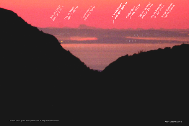
Pic Gaspard (3880m)/Grand Ferrand (2758m) from Pic de Finestrelles (2826m) in the Pyrénées

Image
I have some new toys to share in this installment of 'Yes, the Earth really is Curved even though you can see one distant mountain peak from another', so this should be fun! This time we're going to look at a view of two distant mountains from Pic de Finestrelles (2826m) in the Pyrénées , taken by Marc Bret of Beyond Horizons (see also the Flickr album ). Pic Gaspard (3880m) in the Massif des Écrins range at a distance of 443 km. Grand Ferrand (2758m) at a distance of 392.48 km. Our view is right around 42.414466°N, 2.132839°E at about 2826 meters elevation, looking right along the coast. Pic Gaspard/Grand Ferrand from Pic de Finestrelles in the Pyrénées, image by Marc Bret The EXIF metadata shows this image was taken by a Panasonic DMC-FZ72 with a focal length of 215mm -- given the 5.62 crop factor of the 1/2.3" sensor in this camera, this gives you a 35mm equivalent focal length of 1200mm giving a full frame view of 1.644° wide and 1.215° high. Since 1521 x 101...

Does this iPhone 6s image make my horizon look flat?

Image
A beautiful study in shades of blue of the ocean and open skies just floated across my twitter stream posted by  @mcnees , taken on an iPhone 6s. He was gracious enough to send me a link to the original for this blog (thanks!): It's so quiet and serene, it really is a gorgeous image... But my inner-scientist just had to check... A quick check on my phone using the smaller twitter image confirmed a few pixels of drop off on the right side, so I took the full resolution image and rotated it 0.2° counterclockwise to correct for the slight camera rotation and compressed the width to 202 pixels (1/20 of the original size)... Here is the result: That is about 5-7 pixels high in the full resolution, 4032 x 3024 pixel image. However, from this vantage point, let's say about 20 feet over the water, 4032 pixel wide image, ~ 57.724° Field of View I would expect only about one pixel of 'apparent horizon Sagitta' .  We would have to be about 1400 feet over the water to see 6 pixels...

Guest Post - Observational Evidence We Live on an Oblate Spheroid - by C.A.M. Gerlach

This post comes via C.A.M. Gerlach.  The guest author is a degreed research meteorologist specializing in severe convective weather and societal impacts, currently affiliated with the University of Alabama in Huntsville. Flat Earth Claims: An Observational Perspective C.A.M. Gerlach, CC-BY-SA 4.0 Many a Flat Earth proponent has invited skeptics to neglect the copious volume of indirect evidence that our planet is a rotating oblate spheroid, and just 'think for yourself.' Very well; coming from someone who has, I too invite everyone to experience things and think for themselves. Let's consider the International Space Station, and forget the fact that I've personally spoken to the astronauts on it (must have been actors somehow simulating microgravity, who knows?), and just rely on measurements you and I can directly make. Look up when it is due to pass over your location, noting the elevation in the sky at which it appears and disappears and the time the passes between t...