Posts

Showing posts from June, 2017

Where was my Moon?

Image
A few months ago I took a random picture of the Moon using my Theodolite app (on iPhone 7 Plus), which records the date, time, azimuth/horizontal angle, and altitude/elevation angle, and thought I would check it against a couple of sources: Mooncalc.org data for this date, time, and location Yup, it's where it should be -- I'm pointed low and to the right a bit. Stellarium Moon - Az/Alt: +275°09'58.1"/+29°52'47.0" (apparent) The Altitude is within a fraction of a degree, the Azimuth of my device isn't terribly accurate (it wiggles around actively) because it's based partially on the magnetic reading -- so it's off by maybe 3-4 degrees. To get an accurate heading we need to align to the stars and that's just not built-into phones yet.  I'll be able to do it with my telescope pretty soon but I won't always have that with me -- but that should give me similar accuracy with heading measurements (if not better -- possibly down to a few arcs

Quick Thoughts: Telescopes and the Flat Earth

Image
I don't even know what to do with this information other than share it... Yeah...I heard of your preprogrammed lol telescopes. They make stars look just like the CGI you've seen on TV! Bill Nye certified! pic.twitter.com/oIaPxLuMuo — Gospel Truth (@BadBuc99) June 27, 2017 Does this guy REALLY not understand that it's just a database of where to point in the sky?  There is no projector or imager in the telescopes. You get worse images from these smaller scopes than you get from mine, which is fully manual and you can look inside the tube and even disassemble the tube completely and verify there are just 2 mirrors in there -- the larger one is on the back and the smaller one angles the light up into the eyepiece, which is at the front where the light comes in. Meade LX70 R6 But, of course, the illuminaughty are all powerful and can apparently embed billions of images into the very mirror itself along with sensors so it knows exactly where it is and which way it's pointi

Quick Debunk: Stars would run out of Oxygen

Image
Wow, I don't even know where to start on this one? However, if you are a Christian Flat Earther and you believe that Bearing False Witness is a sin then you might want to try to at LEAST understand the actual model before you bear false witness against it. You can think the model is WRONG but you can't just lie about it. The sun is a fire ball of burning of gas. Fire needs oxygen to burn. Space is devoid of oxygen. How does the sun continue to burn? 🤔🌞 — Good Bonds (@goodbonds1) June 19, 2017 And backup image: Ok -- the MODEL is that the Sun is a giant ball of mostly HYDROGEN gas 1.989 × 10³⁰ kg This amount of mass, thanks to Gravity (and yes, I know Flat Earthers deny gravity but that IS THE MODEL -- and they have yet to actually disprove anything -- and Einstein already 'disproved gravity' because under Relativity it's a fictitious force), creates tremendous pressure which causes some of the Hydrogen to fuse into Helium which releases a tremendous amount of ener

Earth's Rotation

Image
Flat Earthers lie about the Michelson–Morley experiment and claim it shows stationary Earth but that is simply not what it was built to test.  You want the  Michelson–Gale–Pearson experiment (1925), The Effect of the Earth's Rotation On The Velocity Of Light  which very definitely was built for this purpose and gave a positive result. A giant, modern version is just becoming operational and will measure changes in Earth rotation from earthquakes, weather, tsunamis, etc:  Rotational Motions in Seismology ( ROMY) I've also previously posted about the Compton experiment measured the rotation of the Earth using a tube of water with small particulates ( How Compton computed Latitude, direction to North, and length of a day ). Gyrocompasses find geocentric North using the spin of the Earth, here is one in operation: Every major ship in every Navy was fitted with Gyrocompasses around the time of World War II because they are far superior to a magnetic compass -- most big ships today

Quick Debunk: Russianvids - Nikon P900 Digital Camera Sun Zoomed At Sea At Sunset Proves Flat Earth

Image
I can smell Flat Earth BS from further away than a Nikon P900 can zoom into. Russianvid? I guess the Russians are trying to undermine world Education by pushing Flat Earth. Anyway,  Another low quality (stolen?) video proof of 'Flat Earth' cuz zoom right? In reality, just another example of Flat Earthers not understanding how exposure works. We've covered this many times but I put together a quick refresher: So what do we see this video? Um -- why doesn't it get bigger if we zoomed into ii We know that zoom doesn't bring back things that are actually over the horizon: If you want to impress me with your Sunset video make sure I can see some details in the Sun -- ONLY THEN are you getting an accurate measurement of WHERE the sun actually is and what size it is. To do that you'll need to add a good filter or welding class in front of your lens and THEN you'll see a sun that looks more like this: And if you REALLY want to get better data, use an actual quality

Soundly Shows Flat Earthers The Curve

Image
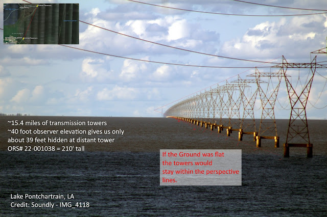
In a rather  devastating series of videos and high-resolution photographs Soundly has shown the best evidence for the curvature over the horizon I've seen [ Soundly's Google Drive ] - thanks to a very long line of equal height towers that stretch over a portion of Lake Pontchartrain.  His first Video includes extended details about exactly where the images were taken. Observation Height: about 40' above water on the bridge North Side: Approximate Location: 30° 4'42.40"N, 90°24'20.98"W South Side: Approximate Location: 30° 4'38.71"N, 90°24'12.66"W Tall Background Tower (210' - ORS# 22-001038): 30°17'37.59"N, 90°18'38.64"W IMG_4118 is my personal favorite of the images, which I color balanced and notated - including the perspective lines for the towers. Where those lines converge is where the horizon would be IF Earth was flat.  That is how the "Vanishing Point" for parallel lines works.  The fact that the

Flat Earth Dishonesty: IF ONLY WE HAD A PICTURE FROM SPACE

Image
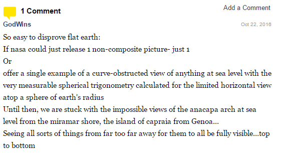
I suppose this strategy is successful enough with people who don't really know much about just how much data we get from satellites but let's jump down the rabbit hole ... Gosh, if only...  And what does he mean "composite" exactly since EVERY COLOR IMAGE IS A COMPOSITE?  I'll assume he means it's not strips of data so I've given numerous examples here of images that are FULL FRAME images of the Earth. They are ALL composites because all digital images are grayscale and color is applied to at least 3 layers of data to give a color image.  That is how your P900 works also.  It has Red/Green/Blue filters in a matrix that filter out that color of light and render a grayscale data on the sensor, which is then COMPOSITED to form the final color image. Because we don't have about a MILLION 11000 x 11000 pixel images from Himawari-8 , the Japanese weather satellite and Himawari-9 coming online now (click for full resolution image, prepare for a big download)

Quick Debunk: Manny's Magic 12,000 mile Solstice Image

Image
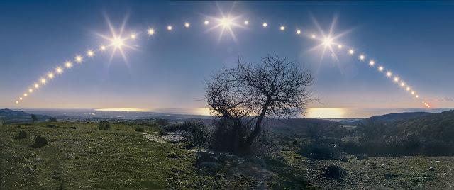
Our spammy twitter friend Manny (now Brian because we assume he got banned for spamming?) loves to make bizarre claims about this image: This is the illusion. In this image, the sun has provided noon to 12 time zones. Then it's going to provide noon to 12 more WITHOUT pic.twitter.com/tkCnrAZ0cm — Brian (@hplarc12345) June 11, 2017 Here is the image: Image Credit: Danilo Pivato © Copyright: - Images 2006 This was also APOD 2007 December 22 , where we learn some details about the image: This series is from the 2005 Solstice It is looking down the Tyrrhenian Sea coast from Santa Severa toward Fiumicino, Italy The view covers about 115 degrees in 43 exposures The sunrise & sunset times for Santa Severa in Dec 2005 were: Sunrise: 7:37 am (121°) Sunset: 4:44 pm (239°) Which are 118° apart. And this is only 9 hours 06 minutes 47 seconds. So this is NOT "12 timezones" as Manny claims, it's only about 9. So it seems that Manny cannot actually look at photographs and magi

Where is GOES-16? [Celestia Recreation]

Image
NOAA posted the following image from the "new" GOES-16 satellite. ( more ) Image Credit: NOAA/NASA Let's use this to validate the reported position of GOES-16 itself using Celestia. Orbit should be between 35,788.1 and 35,798.7 km (35793.4 avg) above 0.0002°N 89.4589°W and this image was from Jan. 15, 2017. I got approximately 20:37Z I have positional data for June but this was taken in January so we've probably drifted a bit East. Celestia CEL Link

Where is the curve?

Image
A collection curvature images. There are three "kinds" of curvature we can readily observe to know the Earth is a very large spheroid. First of all you need to understand that your horizon is NOT the same as looking at "the whole Earth", you can see only a very tiny portion of the Earth until you get a very great distance away (several Earth Radii).  Your view is limited to where your line of sight hits the Earth.  The closer you get the less you can see of the whole.  I tried to demonstrate this effect of perspective here: For example from 35,000 feet your view is still microscopic. Even at 400km where the International Space Station is you still have a very limited view.  This is why Flat Earthers say the whole Earth won't fit in that view -- IT WON'T AND SHOULDN'T. So... Curvature #1 is to observe that your horizon is (roughly) equally distant in all directions -- if it CURVES around you it simply CANNOT also be flat in every direction you look.  That