Posts

Showing posts from October, 2017

Flat Earth Challenge: Estimate Altitude of the International Space Station (ISS)

Image
You can estimate the altitude of the International Space Station (ISS) by measuring the angle to ISS in the sky from two different positions -- however, your observers should not be too far apart or the curvature of the Earth will make your angles more and more unreliable.  You can also use proper spherical trigonometry once you have affirmed to yourself that the Earth is a spheroid (left as an exercise for the reader). As a Flat Earther, would finding out the International Space Station is actually a couple of hundred miles up change your mind?  If you would consider such evidence, then here is the method. You need to get two people together and go out and measure it multiple times -- estimate your margin of error (can you even measure to within 1°)?  Think about how you can make your angular measurements more accurate.  Maybe get a surveyor friend with a Theodolite to take more accurate measurements of the angles if you can. I also posted a shortcut method at the b...
The Horizon Looks Flat? Oh Really?

Image
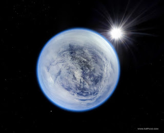
How much has been written on this subject of the 'Horizon Looks Flat'... never enough it seems, so here is another, building on previous posts and based on answering this YouTube comment: Flat horizons everywhere I look at every altitude. How many flat horizons does it take to make a sphere? ~ desMEGA How many "Flat Horizons" does it take to make your horizon go 360° around you?  Anyone standing on a peninsula can observe this: AirPano Caucasus Mountains How does a "Flat Horizon" manage to curve around you at the same time? You'll laugh that off but you know you cannot explain or address it. If the horizon were TRULY flat it could NOT go all the way around you. It LOOKS FLAT because you are looking at a curve nearly edge on and it happens to fill most of your limited human vision. Can any Flat Earther honestly address this? Moving on... Get yourself a Canon EOS 6D (Full Frame DSLR, 5,472 × 3,648 pixels, ~$1400) and a Canon 11-24mm F/4L lens (~$27...

The Flat Earth Gish Gallop

Image
The Gish Gallop is a rhetorical strategy where the person tries to show just how amazingly strong and vast their position is by presenting a litany of arguments all at once, and if you only address 99 out of 100 of them then you get the "AH HA! You can't address how water sticks to a spinning ball!" From the Rational WIKI The Gish Gallop should not be confused with the argumentum ad nauseam, in which the same point is repeated many times. In a Gish Gallop, many bullshit points are given all at once. Indeed - if the Flat Earth argument were strong then ONE demonstration would be enough to destroy the Globe.  But Flat Earth doesn't have even one that will hold up to scrutiny so they would rather throw a bunch of bullshit (technical term)  and see what sticks. One 'Mrs. Butterworth' tried to pull this by proxy in a YouTube comment : Please.  "usually pretty good" but can't address this utter nonsense?  Not ONE of these is even a technical challenge...

Flat Earth Follies: Survey Says...

Image
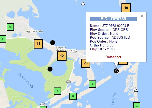
This time around we're going to look at some data using the National Geodetic Survey Data Explorer . I'm just going to pull up some Geodetic Survey marker data for markers lying very near the ocean and we're going to see what shape it describes.  You can see the Ortho Height for each marker is under 2 meters. Click on the link in the caption for each image to pull up the raw NGS datasheet on each one. Our first target is down in the very tip of Texas near Port Isabel... NGS DP0739 In this case we find the NAD 83 XYZ coordinates from the datasheet are: DP0739 NAD 83(2011) X -   -716,721.076 (meters) COMP  DP0739 NAD 83(2011) Y - -5,688,867.995 (meters) COMP  DP0739 NAD 83(2011) Z -  2,784,100.512 (meters) COMP Next stop is New Orleans... NGS BJ1342 Where we find BJ1342 at these coordinates: BJ1342  NAD 83(2011) X  -    -10,884.151 (meters)  COMP BJ1342  NAD 83(2011) Y ...

Deconstructed - Auguste Piccard: “It seemed a flat disk with upturned edge”

Image
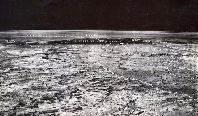
Deconstructed - Auguste Piccard: “It seemed a flat disk with upturned edge” Is it possible he means it looked like an upturned disk?  As in, you see a bit of horizon curvature? Stratobowl image from 1935 The human eye has a wide field of view so you see a bit more of the Horizon Circle than most images and thus more curvature, all else being equal. One reason for this is that this is NOT the "curvature of the Earth" -- this is the curvature of the Horizon Sagitta viewed nearly on edge .  This is a mistake I constantly see people making.  So it's not a circle of 3959 miles diameter that curved downward, but an OVAL that you are in the middle of with, in this case, a 300 mile radius and viewed on edge at a 4.8° angle -- and this oval curves 360° around YOU. As to why it looks flat, it's because the terrain is far away and the curvature is fairly slight and you're looking down on it.  We just cannot see the geometry under these conditions.  You can't even see the...

Curvature on Parade: The Turning Torso video by Mathias Kp

Image
This is a really nice video of a building called the Turning Torso done by Mathias Kp , complete with GPS stamps at different distances (slightly different heights but generally around 3 meters). He's also got the images stored in flickr so you can download them and he has some nice overlays and analysis already done (including one that looks at possible refraction coefficient in each shot).  I took one and added some additional analysis to it, I assumed a fixed refraction for this analysis because all the buildings are scaled to match the first one. I took the image with nearly the whole building and used the visible section to estimate the number of pixels per meter.  This gives me a rough way to convert the Hidden Height values to pixels so we can see about where the bottom of the building would be and see how those match up -- it's not perfect, but since the building is very vertical and the distances are large the error is fairly small. I calculated the estimated Height ...

Flat Earth Follies: Magic Fish-Eye Holes in Airplane Windows

Image
The Hilarious Claim (showing very poor reading comprehension) In response to  @turner_d posting this image to show that airplane windows limit your field of view which makes it harder to see any curvature at altitude: Figure 1 This guy posts the AIRPLANE WINDOW HOLE nonsense! Riiight The Window Argument πŸ˜‚πŸ˜‚πŸ˜‚. Look In2 Why People See A Curve Out The Window Of An Airplane, U'd Be Surprised 2 Find Out. pic.twitter.com/7XhtrECcr7 — Juggernaut (@MarkuzOcampo) October 12, 2017 Reality Read that again carefully... to explain why we CANNOT see curvature from airplanes the Flat Earther says it's because the window is a fish-eye lens... Let me rephrase as a positive statement:  You COULD see the curvature but the magic window hole makes it a fish-eye lens. Ok, I know that isn't what he MEANT, but that is what he said because he didn't bother to read or try to comprehend what David had said. More Reality As explained in US5988566A  the purpose of the hole is to allow the press...

Quick Post: Explorer II, 1935 High Altitude Balloon flown by Stevens and Anderson, first image from the Stratosphere

Image
On the 11th of November 1935, over the skies of South Dakota, a new altitude record of 72,395 feet would be set in High Altitude ballooning and photography by Stevens and Anderson flying the Helium filled Explorer II . The first Explorer balloon used the more efficient and more dangerous Hydrogen, the fabric tore, and the balloon burst into flames with the two passengers narrowly escaping via parachutes. This was the first High Altitude flight to feature a camera. First photograph clearly showing Earth's Horizon sagitta curvature. [ src ] From its vantage point 72,395 feet in the air, the highest point ever reached by man, the camera registers the horizon 330 miles away, sweeping like a great arch across the photograph. The straight black line ruled across the top brings out the curvature of the Earth. The first few seconds of this video shows some of the video footage they recorded (unmarked up): British PathΓ© footage: Book on early ballooning with lots more detail and information...

OH Buoyancy! Flerfers are at it again

Image
OH Buoyancy! How can #Gravity hold all this water 2 a spinning ball but an insect can fly even a Bee a none aerodynamic insect #fake #Sciencelies #truth pic.twitter.com/axC8PhAJby — FE in Cork ,Ireland (@WeAreWakinUp) June 18, 2017 How can Gravity hold all this water 2 a spinning ball but an insect can fly even a Bee a none aerodynamic insect pic.twitter.com/ZOocdsiIIy — Chester Lee Raniego (@god640) June 20, 2017 pic.twitter.com/sUK6rOodNY — Jack "The Carpenter" (@Adidas68Jack) October 11, 2017 There are 100's more of these -- many of them exact duplicates across numerous accounts which makes me suspicious ... but on to the science. So how does a force that pulls everything towards the center of the Earth manage to push lighter things up? tl;dr version of  Archimedes '  principle Cut a small hole in the bottom of a bucket Feed a string through, tie it to a small ball Fill bucket with BBs Pull string really hard Observe that the BBs rise as the ball burrows down,...

Rob Skiba's Second Balloon Launch - Image Analysis at 95,733 feet

Image
Rob Skiba's Second Balloon Launch - Image Analysis at 95,733 feet (29179 meters) I've been vaguely aware of this for a while but I haven't really had a chance to go look at it before now: I gotta say, huge thanks to Rob Skiba for proving the Earth is a globe -- so I'm going to keep this one fairly short and simple. It's a shame that they didn't use something like the Canon 11mm lens on a real camera (126° FOV!) -- but we will have to make do with their tiny 47° Field of View 7.2mm GoPro "non-fish-eye lens". So around 1:48:30 in the video we are treated with the following view from 95,733 feet up -- according to Rob Skiba and friends: Figure 1. Rob Skiba YouTube video circa 1:48:30 There is very clearly about 10 pixels of what I call the 'apparent horizon Sagitta '.  The horizon is curved, it matches what we expect on a Globe of approximately 3959 miles radius. Flat Earth is DONE... Right? (LOL if you think Flat Earthers will believe their OW...

Flat Earth Follies: Nikon P900 Superzoom: FLAT EARTH PROVEN- Superdome Seen From 26.55 Miles Away

Image
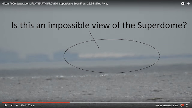
The claim: Nikon P900 Superzoom: FLAT EARTH PROVEN- Superdome Seen From 26.55 Miles Away The "evidence": A blurry white splotch in a shitty P900 video: Figure 1. I'm pretty sure I see bigfoot in this image (why is all their evidence blurry?) Wow, that's pretty incontrovertible, I can see why Flat Earthers immediately scream "FLAT!" Figure 2. Google Earth Eagle's Eye View - 26.45 miles I get 26.45 miles (139656 feet), but ok.  But that's a LOT of city missing to get to the Superdome. Here is what our skyline should look like from this angle, according to Google Earth. Figure 3. Skyline From This Viewpoint Let's sketch out the skyline from the video in this frame: And now we can scale and overlay our skyline The Superdome is 253 feet high so yeah, refraction would be required to bend light towards the Earth because it is, generally speaking, more dense. I freely admit that without refraction you wouldn't be able to see the Superdome from here -...